Here Comes The Rain Again
The title might not be what you’d expect to hear from someone traveling around the Red Centre of Australia, but appearances can lie. We’d been told that the desert had gotten more rain than usual on the way up, but we shrugged that off – it’s a desert, right? Strange thing though: I never thought deserts were green…
Our first stop after Coober Pedy – and a long, straight, boring drive – was Curtin Springs Station: a slight deviation from the Priscilla trail perhaps, but also the last stop on the Lasseter Highway before Uluru-Kata Tjuta National Park (the one with the big rocks). This is a really lively place and one I’d recommend to anyone camping around Aussie: free camping, great bar, crazy station hands, mad backpackers, and some of the cheapest camel rides in Central Australia. They even have the third big rock, Mt Connor (aka Atila) close by, which is apparently twice the size of Uluru but looks more like Table Mountain. All this, and only 45 minutes drive to the National Park (where camping is about $30 per night).
We’re off to see the… big rock
So off we drove the next morning, noting the clouds with little worry – it’s a desert, right? – and looking at all the bright, colourful flowers blooming under the Aussie sun. Entry is $16.25 per person and valid for three days, covering both Uluru/Ayers Rock and Kata Tjuta/The Olgas, and all the maps and info you need can be found at the helpful Visitors Centre in Yulara, the Park’s resort, or the Cultural Centre closer to Uluru. There’s also a shopping centre in Yulara if you need to stock up on food, plus a decently priced fuel’n’ice stop round the corner – pretty rare.
|
|
|
Uluru up close
|
![]()
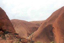
Up close Uluru really is quite impressive, though a lot more pitted and grooved than the photos tend to show, and every bump in the landscape seems to hold importance in the local Anangu tjukarpa (natural law). This remains the only place where I have seen Aboriginal beliefs put forward so strongly, and the Cultural Centre is fantastic in teaching us tourists this, probably because of the struggle to advise people against climbing sacred Uluru.
Of the three of us, Jen was the only one of us determined to climb The Rock, mainly as a personal challenge, but she was thwarted by the sky: the path is usually closed from 10am onwards due to heat, but also for forecast rain or wind. We did, however, do the short Mala and Mutijulu walks during our visits to Uluru, using the $1 guidebook from the Cultural Centre to look at the story places – then running for shelter when the heavens opened. The waterfalls cascading down Uluru were a sight to be seen though, and it used to be a rare one until recently – this year has been the wettest in 25 years but the last couple have also brought a lot of rain. No wonder the ‘desert’ is so green!
|
|
|
Sunset camel ride
|
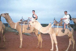
![]() That evening we took up Mark the Cameleer’s offer of a sunset camel ride out over the dunes and clambered aboard – $25 for an 1� hour trip. He’s been working with them for years and even rode across Oz from the west to east coast a couple of years ago, and he certainly seems to know what he’s talking about – though apparently they left the fourth wise man out of the Bible story: the one who brought the six-pack! It was really good fun, bumbling along up and down with Mt Connor in the distance – especially when you’re riding a crazy camel named Ned Kelly 🙂
That evening we took up Mark the Cameleer’s offer of a sunset camel ride out over the dunes and clambered aboard – $25 for an 1� hour trip. He’s been working with them for years and even rode across Oz from the west to east coast a couple of years ago, and he certainly seems to know what he’s talking about – though apparently they left the fourth wise man out of the Bible story: the one who brought the six-pack! It was really good fun, bumbling along up and down with Mt Connor in the distance – especially when you’re riding a crazy camel named Ned Kelly 🙂
Our third morning in Curtin Springs dawned with a revelation, however: our tent, while waterproof to a point, had not managed to keep the night’s downpour at bay. Jennie’s airbed was practically floating! Ye gods ‘n’ little fishes (though I didn’t see many of them), thought we, and promptly pulled down the tent and scarpered into the bar area. After booking into a double room for the next night (with muggins here on the floor), we toddled off to see Kata Tjuta – also known as the Olgas – with a short stop by a purple-ish Uluru to admire the ever-tumbling waterfalls.
Kata Tjuta may not be as awe-inspiring to most as Uluru, but I loved them. Lots of mini-Ulurus clustered together like a bunch of elongated marbles (ok, so it sounds weird, but different to the usual description of many heads!). There are a couple of walks set up for visitors, but we only did the short Gorge Walk due to all the rain – very very nice, but the Valley of the Winds walk (closed) comes more highly recommended. Maybe I’ll just have to get myself back there someday!
|
|
|
Flowers in the desert
|
![]()
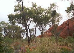
And finally the third day of our Park tickets dawned, but after two days of rain and another looking like more it didn’t seem worth driving there in the hope of catching a sunset later on or in case the climb was open. Annoying, but everyone and their sister has piccies for sunset over Uluru – how many have piccies of rain and flowers in the desert? The worst bit for me was that with all this rain, the road northwards to Watarrka National Park (home of Kings Canyon and back on the Priscilla trail) was in danger of flooding – at least to 2WD Ford Falcons – and the unsealed Mereenie loop round to Alice Springs was closed.
Drive straight to Alice we thought, check out the forecast, tour prices and road conditions from there. A flooded tent is bad enough, but a dead car would be the end of our travels for a while!
Alice, ALICE!!! Who the… (I’ll shut up now)
Take one large country, add a few ex-pats and place a telegraph line right through the middle so’s they can ring home: therein lies the origin of Alice Springs, final destination of the great pink bus. It’s a pretty town, with loads of gorgeous jacaranda trees in the town centre, and plenty of backpackers seeking the best/cheapest tour in the area. It’s also a fun place to cycle around if you don’t have a car, but being 500km away from the main tourist spots, the sun was naturally out and glaring down upon all.
We booked into Annie’s Place (home of Mulga’s tours, who stop at our old drinking hole, Curtin Springs!) for another night in a dry bed, a colourful and lively hostel close to town and with cheap, tasty meals for guests. Yummy yum yum, Chuck in a bunch of Irish and Welsh lads and you get a night of drunken hilarity – just the ticket! The next night Rob ‘n’ I decided to dry out the tent in the sun at Gapview Resort – a hotel with some grass out the back, much closer to town than the caravan parks areas and with free barbeque facilities (used to full advantage). A new trend also emerged at this point: Jen has gotten fed up with camping, being a bit more of a townie than me ‘n’ the Kiwi, and now stays in hostels at every opportunity.
So, things to see and do in Alice. After confirming that driving the short way to Kings Canyon wouldn’t be possible and deciding against a 1000km or so round trip for the sake of one sight, we looked at tours: the cheapest day trip was $150, taken up by Jen but falling by the wayside for Rob and I. Off Jen trundled the next morning, and we lazed about for most of the day – mmmm… Unfortunately it rained on her, again – nice views though.
There’s been the dream of an Adelaide to Darwin railway for over 100 years, but it’s still a dream. The Ghan has linked Alice to Adelaide since before WW2, when it was essential in getting troops up north, but the old line has been modernised while the Northern Territory is now funnelling in resources to complete the second leg to Darwin by 2003. We went to the Old Ghan museum which preserves the history of the original route and renovated steam engine, plus the original Stuart Station (Stuart being the name for Alice Springs until 1930). The surveyors thought that dry rivers could never flood and mistakenly laid tracks across so many that most of the line had to be rebuilt after the rains came each year. Doh!!
|
|
|
Driving towards the MacDonnell Ranges
|
![]()
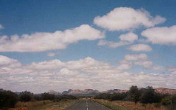
The next day we tackled the West MacDonnell Ranges – though by car rather than along the extensive bush-walking track – which has a series of gorges breaking up an impressively craggy mountain range. We went to the two closest to Alice, arriving at Standley Chasm around about midday. The mountains look quite craggy and dramatic in any case, but this crack in the rock is only 2m wide in places with sheer walls on either side, so the sun hits the bottom for only 30 minutes each day. Luckily we not only got there in time to enjoy the light, but also just before a huge party of schoolkids cluttered the narrow spaces. Close by is also Simpson’s Gap (a 15km cycle ride from town for the energetic), where you walk along a dry river bed full of gum trees until the gap in the rock and small pond – not as impressive as Standley Chasm but certainly very peaceful.
Next up was a trip to Anzac Hill, a great lookout over the town – but little else. So back down the hill we went and off to the Alice Springs Cultural Precinct, a collection of museums and galleries about Central Australia’s landscape, history and art. Very interesting in parts, and we saw pieces of meteorite which created the 13 < a href="https://www.nt.gov.au/paw/parks/alice/henbury.html">Henbury Craters between Alice and Erdlunda (the turn-off toward Uluru) – didn’t look that big, but the holes it made still are after a few thousand years of erosion! There’s also the remains of the Kookaburra, whose crew crashed in the Tanami Desert while searching for friends in another downed plane – though only the latter survived.
|
|
|
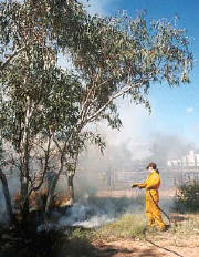
Controlled burning by the park rangers
|
![]()
And finally we visited the original Alice Spring, up at the Alice Springs Telegraph Station – though it wasn’t very impressive I can tell you. Apparently this small pool of water was misnamed as it isn’t a spring but a mere ‘window in the watertable’ (don’t ask me what that means), but it sits quietly on the bed of the Todd River while locals have picnics around it. Lovely… but I kind of thought we’d see more. The rangers were doing a controlled bushfire however – with all the rain comes plenty of vegetation, which is a worry for most of the Territory because this year’s fires will be worse than ever if steps aren’t taken to clear some of the dry grass now.
But there we have it: a quick guide to Alice, and it was back on the road the next day, up toward Tennant Creek and the Devil’s Marbles, a strange collection of gigantic round boulders.
Ka-thunk
Yes folks, we didn’t quite make it to the Devil’s Marbles – though we did get towed through them to Tennant Creek. Doris blew a tyre just before Wycliffe Well Roadhouse. Easily changed, but when we stopped at the roadhouse – UFO Capital of Australia, complete with little green men on the forecourt – the starter motor jammed and nearly drained the battery, then simply refused to work.
Tennant Creek, we discovered, is a very small town (though one of the largest between Alice and Darwin) with little to do but walk up and down the main street. It may be the ‘Golden Heart’ of the Northern Territory, but that doesn’t mean there’s much to keep you occupied.
Unfortunately we had broken down after hours on a Friday night, and the garage wouldn’t open again till Monday, and while the invaluable NRMA Plus gave us a hand by paying for most of the tow and three nights accommodation in a motel room with TV, fridge and air conditioning, this didn’t compensate much for being in the back end of nowhere. Still, we sat it out by playing cards and catching up on news and motorsport, bumped into a few backpackers in the campsite we stayed in on the last night (once it’s vaguely fixed, NRMA say bye-bye), and trundled back onto the road on Tuesday morning, vowing to return for a look at the Devil’s Marbles after a visit to the Top End.
There may only be one main road from the Northern Territory into Queensland, but it starts at Tennant Creek – nearly 1000km south of Darwin, our next destination. Dead or no, we’ll be back.
