You may arrive in Toronto by car from the USA: the closest border crossings are at the Peace Bridge (Buffalo, New York) and the Queenston-Lewiston Bridge (Lewiston, New York) about a 90-minute drive from downtown Toronto. You may also arrive directly by bus, railway, or air. The central bus station is in the Edward Street-Dundas-Bay Street area right in the downtown core and near two subway stops. From here, direct buses of various lines depart to various parts of Ontario, other provinces and the United States. Usually, no reservations are necessary and there are frequent daily departures to Ottawa and Montreal.
Union Station on Front Street is the railway depot served by Via Rail (Canada) and Amtrak (USA) and is an architectural tourist site on its own. Train service is not as frequent as in Europe except to Montreal and Ottawa but it is possible with careful scheduling to get to some tourist areas outside the city for day trips like Stratford, Cobourg and Niagara Falls. Union Station even has its own subway stop (called Union, what else?) on the Yonge Line. See www.viarail.ca for more detailed information. It was the former CNR (Canadian National Railway) and CPR (Canadian Pacific Railway) which originally bound this vast country together from east to west. The CN Tower, the structural ‘symbol’ of the city’s skyline is on Canadian National land.
If you arrive by air, you’ll be at Pearson International Airport in Malton, some 20 kilometres from downtown (all measurements in Canada are in the metric system, except for clothing sizes, which are basically North American). There are three terminals at the airport and an excellent bus service from all three via Pacific Western. The buses go downtown and three subway stations, the closest and least expensive being Islington on the Bloor Line.
However, if you are three or four people sharing a taxicab, check out what the rate will be and it may pay to share the fare. At the beginning of June 2000 there were many foreign airlines that switched terminals and BOTH Air Canada and Canadian Airlines (now merged) now fly out of Terminals 1 AND 2, depending on destination. So check your departure terminal carefully!

The TTC is the Toronto Transit Commission, consisting of two subway lines (a third, the Sheppard Line, is nearing completion), a fleet of buses and electric streetcars (fondly called Red Rockets) in the city core. In addition, there is an LRT (Light Rapid Transit) line along the harbourfront and the Scarborough LRT connecting with the Bloor Line (handy for getting to the Metro Zoo). Subway service is usually from about 5:30 a.m. to 1:30 a.m., but reduced after rush hours and on Sundays/holidays.

![]()
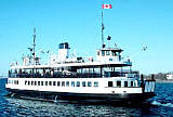
A long and fun streetcar ride is from High Park in the West End of town all the way to The Beaches in the East End. There are student and senior rates and also some all-day passes available so inquire or visit their web site at www.city.toronto.on.ca/ttc. This site is an excellent source for maps and links to other urban and suburban transport systems including the Toronto Island Ferries so you can see the Toronto skyline from the water.
Speaking of water, there is now a tourist boat service in season to Niagara-on-the-Lake and the New York State side of Lake Ontario – more on this in a future write up on day trips out of the city. Besides, at Harbourfront behind the Queen’s Quay Terminal building, there are a few companies which do cruises of the inner harbour and Islands both day and evening.
If you are staying in the downtown core (from Queen Street north to Bloor and Yonge Street west to Bathurst) many tourist attraction are within walking distance depending on your time and energy. Driving is a pain in the city centre and free parking is very hard to come by, so even if you arrive by car, consider parking it and using public transport. Save a car rental for the harder to reach places outside the greater Toronto area.
Have fun exploring this cosmopolitan city by rail, bus, boat and oh yeah – don’t forget: those boots are made for walkin’!