For the last few days, the words Ciudad Perdida had been going around in my head. Somewhere in my brain, a light was blinking. Hadn’t it been mentioned somewhere in that long publication on the Foreign and Commonwealth Office website? It certainly had cropped up as a bit of a buzzword around the odd gringo in Santa Marta.
The following night in the bar, I talked to a few chaps. The words tough, jungle and Indians were mentioned, along with kidnapping incident, guns and gringos. That caught my attention. I found a late night internet café, checked the Foreign and Commonwealth Office website again. We also advise against all travel to southern parts of Meta department and to the Sierra Nevada de Santa Marta (including the "Lost City"). There is a high risk to your personal safety in these areas.”
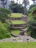
The Lost City, Ciudad Perdida, is nestled deep in the mountainous jungles of the Sierra Nevada de Santa Marta. It takes approximately 2.5 days to trek. I went to the hotel in downtown Santa Marta where you can book the trip. You can even talk with some of the original band of Tomb Raiders who discovered the Lost City, purely by chance, in 1975. These guys now run guided treks into the region; rather than scratch a living with occasional small jackpots searching for ancient grave goods.
The first day of the trek begins with our driver getting arrested for a minor traffic offense. The police enjoyed teaching him a lesson by making him unload the entire roof luggage, then told him everything was fine and he could put it all back up. It takes an hour of battling our way through the Tuesday morning traffic followed by another hour’s drive along the main route between Santa Marta and Barranquilla. We stop for arepas, corn based food dish, and shots of rough black coffee. When we reach the turn off on the asphalt road, the two jeeps begin the slow and precarious climb up into the foothills of the Sierra Nevada de Santa Marta. We have to walk behind the vehicle on two occasions as the drivers negotiate the tight squeezes where the road has partly fallen away into deep forested canyons below.
Three cheery young farm boys with their trademark long machetes in their tasselled scabbards, skip past in Wellington boots, their jeans caked in mud. At the start point, we walk for 20 minutes, stop for lunch beside a crystalline river, slowly allowing ourselves to become accustomed to the multiple jungle odours of dank earth, decomposing vegetation, flowers, shrubs and vines.
The climb takes approximately eight hours each day on a 70% gradient of mud filled switchbacks, heavily eroded by rain, donkeys and occasional trekkers. By about 6:00 p.m., I start thinking that we are close to our accommodation – it's late, there are several small houses at the bottom of the trail ahead, before the river. I walk in the midst of the houses; no trekkers, two small boys sharpening machetes on a wet stone. I look for more signs of life – a topless man, a moustache wreathed in tobacco smoke, silently watching the muddy, damp human traffic slowly passing by.
I correctly assume there is no further to go, tilt my head towards the smoker in a silent hello and press on into the quickly growing dusk. We spend the first night at a mud built farm, with chickens and a few pigs and cattle, nudging the supply of smelly blankets like vultures. I am without a blanket. I shiver.
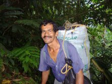
The next morning the guide tells us, in rapid Spanish, that those with a lot of gear should leave non essentials at the farmhouse to be picked up on the return. The climb is strenuous. We are ok, carrying one half full of a 30-litre rucksack between the two of us. We set off after a light breakfast, struggle up the steep, muddy red gash in the undergrowth that leads upward past the last of the farmed fields and into the gloomy primary forest.
The heat of the day is taking its toll, I think, as I hear someone retch their breakfast into the undergrowth far behind. Despite the fact that there are eighteen of us, we spend much of each day alone, stringing out along the trail in twos and threes, as the heat and humidity separate the seasoned from the non seasoned trekkers.
On day two I think we've crossed four mountain size dense jungle ridges, the hard way, against the grain. Your mind plays tricks on you in 90% humidity, 35 degrees Celsius – without more than a five-minute break every few hours (the moment you stop, you're covered in mosquitoes to the extent that it borders on the comical).
The second camp is more comfortable. Upon arrival, I walk straight into the crystal-clear, fast-flowing river to clean the sweat from my wet gear. I'm warmer this night, I pilfered a smelly blanket from camp. We drink cheap rum and a few beers.
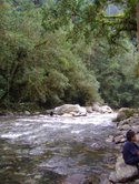
Our third day begins with a waist-deep river crossing. The river is fast, five of us band together to form a human chain to get the baggage to the other side. I battle to stay up in the current, when several of the larger packs are passed to me as my trousers “flag-pole” and threaten to sheer my feet from the slippery surface of the circular stones. The day consists of eight river crossings. We had to climb a few precipitous parts of the trail, up, into and along the valley wall, dirt and vines falling on us from above.
Opposite our final river crossing, I notice mossy steps leading mysteriously upward into the gloomy rainforest. We are close. There are approximately 1,200 vertical steps, cut and shaped by the Tayrona, ancestors of the present day Kogi Indians – around 600 years ago. After climbing these slippery and steep steps for fifty minutes, we stumble into the Lost City in heavy rain – thunder and lightening crashing and flashing around us. The thunder reverberates all the way down through the valley below, hidden from view by the clouds we are standing in.
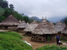
The first structures consist of a few circular walls about two meters high, heavily encrusted with a long, light green moss. As I walk around the first of these structures, I feel slightly underwhelmed. How does this constitute a city? Hearing the calls of one of our party who sounds lost. I silently round the building and make a concerted effort to scare the shit out of him. “Very funny!” he exclaims as he picks himself out of the mud. “Where is everybody?” “Don’t know, but I assume they have gone up there”, I say as I point to the wide elaborate stone stairway I haven’t noticed before due to the trees.
I clock the first soldier five minutes later at the top of an ancient stairway, wearing a poncho, looking pissed off. We are on our own by this stage. We walk by with little more than a nod to the gunman, unsure if he is an actual soldier, FARC or ELN. A little further into the spectacular ruins, a second soldier appears. I have to assume from his insignia they are not FARC. He silently points in the right direction, but for a while I find it hard to shake the feeling we have been nabbed.
We know there are government troops in the area to protect EL Presidente, due to arrive the next day. For the next 20 minutes we climb silently through the overgrown ruins past more soldiers. At least we won't be lonely. Before a final crossing, we catch up with two of the Aussies on the trip, being helped across by the troops. One looks over her shoulder at us with a dubious expression as they disappear around the next corner.
We meet up with the rest of the group at the camp that consists of a two-storey hut that can sleep around twenty-five people, top to tail. There is a campfire – kitchen, makeshift shower/toilet area constructed from Hessian sacks stitched together to afford some privacy. We dry off, settle in on our slightly odorous mattresses, a welcome change from hammocks.
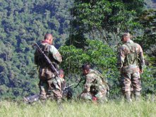
Later we drink coffee, interact with the soldiers who are waiting for El Presidente’s arrival the next morning. It turns out these men spend months at a time in the jungle, moving from map reference to map referenc, collecting air drops of supplies and ammunition. They are naturally quite pleased to see us. Soon they are displaying their weapons and hand the nearest female a 5.56 millemeter Galil assault rifle, with a fair bit of posing with gringos and soldiers.
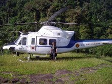
There is a lot of chopper activity, I grab my camera, descend to the main ruins to welcome El Presidente – of Royal Caribbean Cruises – and the Minister for Tourism. So much for rumours. Many local Kogi Indians show up, along with their Chief/Shaman, chewing coca – a great photo opportunity.
I spend the rest of the day exploring overgrown ruins while my partner rests for the descent the following morning. We trek back as far as the first camp from day one, in less than nine hours. Responding to the call of nature, I step outside, unaware that a light rain has fallen. I promptly fall on my arse after a cartoon-esque rapid foot movement and slide into my sleeping quarter.
We are invited to visit a cocaine factory the following day. "Cool, where is it?". "You’re standing in it." "Really?” There follows a demonstration of the production of one of Colombia’s most famous handicrafts, although the term “cottage industry” is more accurate.
When we eventually climb down from the mud splattered jeep in downtown Santa Marta, we collectively look like a scene from The Bridge on the River Kwai – satisfied smiles and a cheeky glint in our eyes.
We endured, saw a lot, met farmers, soldiers and statesmen – in spite of government warnings that the region was unsafe. I did not feel threatened. It’s never black and white, is it?